
| The Ocean Hemisphere Network Project (OHP), supported by a Grant-in-Aid for Creative Scientific Research (New Program) from the Ministry of Education, Science, Sports and Culture (Monbusho), was carried out during 1996?2001 to obtain new observational findings that will provide a new view of the Earthfs interior. For this purpose, a network of multidisciplinary geophysical observatories was constructed and long-term observations were carried out in the Ocean Hemisphere, especially in the western Pacific region, which has long been recognized as the largest spatial gap in terms of global coverage of geophysical data. The OHP began in 1996, involving the collaboration of more than 50 scientists from the University of Tokyo and other universities and national institutions. The total budget was approximately 1,700m yen for the 6 years of the project. The Ocean Hemisphere Research Center (OHRC) (involving both scientists and support staff) functioned as the core of the entire project both in terms of research activity and management. The project ended in 2001 with the completion of the OHP network (Fig. 2.1.1) of 14 onland broadband seismic observatories (most sited on Pacific Islands), three seafloor borehole seismic observatories, 10 onland geomagnetic observatories, one seafloor geomagnetic observatory, seven submarine cables used to measure geo-electric field variations, 19 GPS stations, five stations for superconducting gravimetry, and a data center (see also Sections 2-5 and 2-6). Analysis of data from this multidisciplinary geophysical observation network, as well as data from temporary observations and existing observatories, has led to the publication of significant scientific results. The major outcomes of the project are summarized below. |
| (1) Discovery of the Earthfs background free oscillations |
 |
| A surprising phenomenon was discovered, in that free oscillation of the solid Earth occurs continuously even in the absence of excitation by major earthquakes. The first discovery of this phenomenon was made from a time-series analysis of data from superconducting gravimetric stations of the OHP network (e.g., Suda et al., 1998). As shown in Section 2-4, scientists in the OHRC have consistently led this new area of study from its initial discovery to demonstrated proof of its global nature and subsequent development of the research field. |
| (2) Whole mantle seismic tomography |
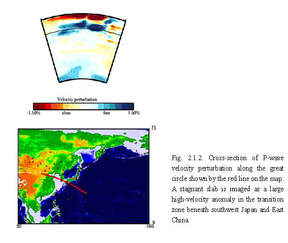
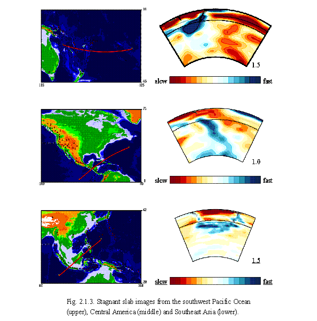
| A new method of whole mantle tomography has been developed that is optimized to image a particular part of the mantle?the mantle beneath the western Pacific region where the OHP network was deployed in the present case?with the highest resolution. This method has been termed the 'non-uniform grid method', and has been used in a number of studies. This method provides a clear image of underlying high-velocity material in the transition zone that indicates stagnation of the slab material supplied from the western Pacific subduction zone (Fig. 2.1.2). The concept of a 'stagnant slab' was first proposed on the basis of these results. This concept is contradictory to the concept of slab penetration proposed by the MIT group, and therefore caused great controversy, related in part to the problem of whether mantle convection is single- or double-layered. Later improvements in the amount and quality of data (Obayashi et al., 2003), as well as inversion schemes and tomographic studies at much larger scales, have revealed the presence of stagnant slabs in transition zones within various circum-Pacific subduction zones (Fig. 2.1.3), thus demonstrating its global nature (Fukao et al., 2001). Thus, the OHP tomography group made a significant contribution to understanding the physics of mantle convection. |
 |
 |
| (3) Study of fine structures of the mantle transition zone |
| Seismic investigations were performed in the western Pacific region to reveal detailed structures of the mantle transition zone, which are considered to be one of the major factors controlling convection patterns in the mantle. Two important results were obtained from this project. The first is the discovery of new seismic discontinuities/reflectors in the uppermost part of the lower mantle at depths of 900?1200 km, immediately below the stagnant slab (Niu and Kawakatsu, 1997; Vinnik et al., 1998; Fig. 2.1.4). This newly discovered discontinuity/reflector is considered to be strongly related to an abrupt change in the tomographic image at approximately 1200 km depth. The second main result is the successful estimation of the density distribution in the transition zone beneath Japan (Kato and Kawakatsu, 2001). This was the first case in the world of an in situ estimate of density distribution, which is considered to be the most difficult challenge in seismology. This study clearly showed that it is possible to determine the density distribution within the transition zone, which is one of the sources of the driving force of mantle convection, by applying the method introduced in this study to data analysis from different regions. |
 Fig. 2.1.4. Seismic discontinuities/reflectors beneath the Indonesia arc. Upper: map view. Middle: location of discontinuities/reflectors. Lower: tomographic image of the region (after Vinniki et al., 1998). |
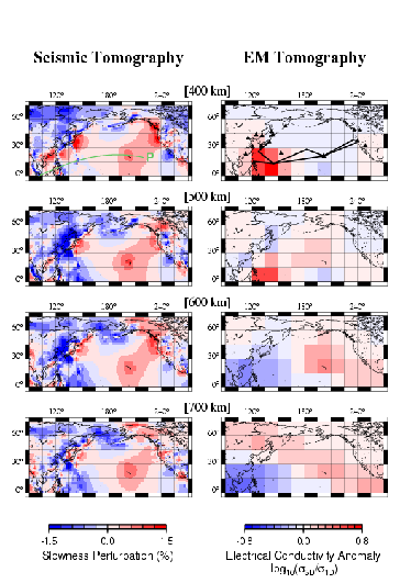 Fig. 2.1.5. Comparison of EM tomography (right) and P-wave tomography (left) of the north Pacific region at the depth range 300-800 km at 100 km intervals. |
| (4) Semi-global mantle electromagnetic tomography |
| An effective code was developed for forward and inverse problems of 3-D electromagnetic (EM) induction. Using the inversion code, EM response functions estimated from geomagnetic and geo-electric data derived from OHP geomagnetic stations, the OHP submarine cable network, and existing geomagnetic observatories, were inverted to a 3-D electrical conductivity distribution (Fig. 2.1.5). This distribution is defined as a perturbation of conductivity, from a semi-globally averaged 1-D reference (Utada et al., 2003), in the upper and mid mantle for the quarter of the globe that is centered by the North Pacific Basin (Fukao et al., 2004). A joint interpretation was attempted for the EM and P-wave tomography, assuming that both are ascribed to temperature anomalies. Results of this interpretation indicate that major anomalies, such as the conducting and low-velocity anomaly beneath Hawaii and the resistive and high-velocity anomaly in the lower part of the transition zone beneath the Philippine Sea, can be simply explained by temperature anomalies of 100?200 K. However, the conducting anomaly in the upper part of the transition zone beneath the Philippine Sea is not accompanied by a seismic velocity anomaly. This indicates that an additional effect is necessary to consistently account for these features. |
| As one of the post-OHP science programs, the Stagnant Slab Project (SSP) was proposed as a 5-year project and funded in 2004 by a Grant-in-Aid for Scientific Research in Priority Areas (MEXT) to carry out an intensive and multidisciplinary study on mantle dynamics with the key term of gstagnant slab.h The project is organized by eight subgroups (three in seismology, one in EM, two in high-pressure science, and two in computer simulation). The total budget of approximately 1,400m yen will be supported for five years. More than 70 scientists are participating this project from more than 10 research institutions throughout Japan. Again, the OHRC plays an important role in both research activity and project management of the SSP. Various collaborations in this project are expected to lead to a better understanding of the mechanism of slab stagnation and subsequent descent of the slab into the lower mantle, as well as further reveal the effects that these processes have had on the history of plate motions and the entire Earth history. |
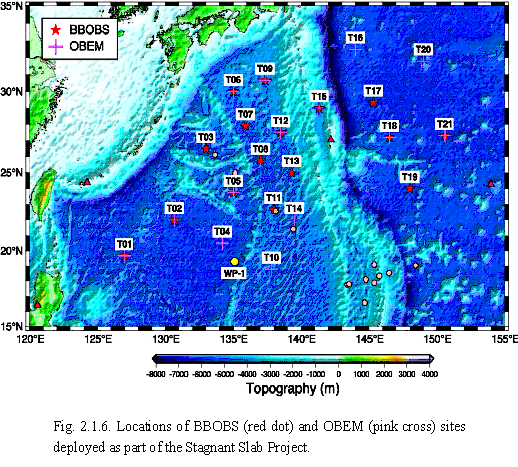 |
| Scientists in the OHRC are involved in two subgroups that carry out long-term seafloor seismic and EM observations to provide datasets for high-resolution seismic and EM tomographies, particularly for the region beneath the Philippine Sea where a vast amount of slab material is stagnant within the transition zone. In October 2005, the first SSP cruise was carried out by the R/V Kairei of JAMSTEC (Japan Agency for Marine Science and Technology), in which 16 broadband ocean bottom seismometers (BBOBSs) and 11 ocean-bottom electro-magnetometers (OBEMs) were installed (Fig. 2.1.6). These instruments will be recovered in 1-years time, when a second set of instruments will be deployed at mostly the same locations. By repeating such installations, a three-year observation using BBOBSs and OBEMs is planned to provide more reliable datasets to improve the resolution of seismic and EM images of the stagnant slab and surrounding area. These two research groups will thus contribute to the goal of the SSP by determining the distribution of physical parameters that control mantle dynamics. |