
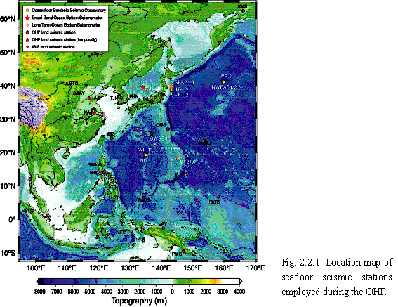
| Since initial experimental attempts at the Japan Sea in 1989 and the Atlantic Ocean in 1992, there have been few broadband seismic observations on the seafloor until the OHP began practical observations in 1999 in the northwest Pacific Ocean and the Philippine Sea. From the beginning of the OHRC in 1997, we have been developing broadband and long-term seismic observation systems for the seafloor that are able to interpolate the global seismic network, which has only sparse coverage over large oceanic areas; this is a principal goal of the OHP. Two types of systems have been developed: the Seafloor Borehole Seismic Observatory (SBSO) as stable stations within the global seismic network, and BBOBS for long-term but mobile array observations. These systems are based on our long experience of ocean bottom seismometer development, and were developed in cooperation with members of the Earthquake Observation Center (ERI) and JAMSTEC. Figure 2.2.1 shows the locations of these stations during the OHP period; this represents the first step for ocean bottom broadband seismology. After several successful experimental observations by the BBOBS, we began practical array observations in 2003, as described later in the text. |
 |
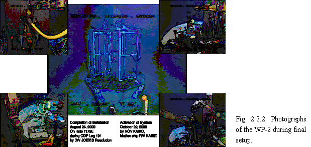
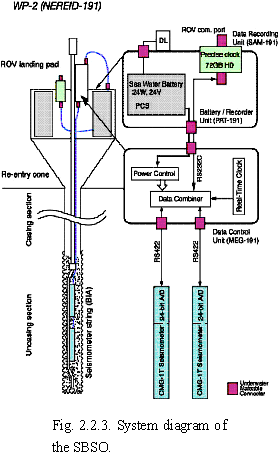
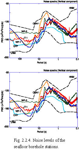
| The four SBSOs were constructed as part of the ODP program to drill the boreholes and install the heavy main unit on the seafloor, with the final setup and maintenance performed using the ROV "KAIKO" (JAMSTEC). The JT-1 and JT-2 stations were built in 1999, mainly to monitor seismic and geodetic signals on the continental shelf in areas with different background seismic activities. As part of the global seismic network, WP-1 and WP-2 have been working since 2001 and 2000, respectively. These stations have two sets of broadband sensor units cemented in place near the bottom of the borehole, and data is stored at the re-entry cone (Fig. 2.2.3). At the WP-2 station, we have successfully obtained data over a period in excess of 400 days, which has yet to be bettered by any seafloor borehole seismic station. The data quality is also good compared to previous seafloor borehole seismic stations, as shown in Fig. 2.2.4; noise level is low and stable over time, comparable to a quiet inland station (Araki et al., 2004; Shinohara et al., 2006). |
 |
  |
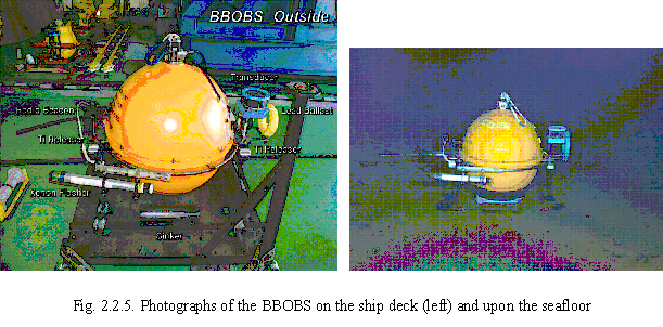
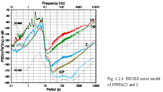
| A trade-off of the SBSO's high performance is the difficulty in increasing the number of stations. To address this problem, the mobile BBOBS and long-term OBS (LTOBS) have been developed to compensate the global network and perform array observations to achieve better spatial resolution; these are operated by free-falling deployment and self-popup recovery. The BBOBS (Fig. 2.2.5) has a titanium sphere (D=65 cm) that contains a broadband sensor with a leveling unit, a data recorder with a high-precision clock, an acoustic transponder unit, and lithium cells for power supply. The LTOBS is similar to the BBOBS, although the sensor does not provide long period coverage and it has a smaller sphere (D=50 cm). After the first experiment with the LTOBS at the East Pacific in 1997, the first BBOBS (NWPAC1) was deployed at the same position as the WP-2 in 1999, with successful recovery in 2000. From the 1-year data by the BBOBS, the noise model is indicated with that of the KIP land station (Fig. 2.2.6), which shows good performance in the vertical component. The reason for the relatively high noise level in the horizontal components is probably tilt variation of the BBOBS sphere due to tidal bottom current. To reduce this noise level, we are now developing a new generation BBOBS system with a separate sensor package that is stuck in the sediment but is still mobile. |
 |
 |
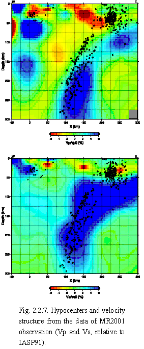
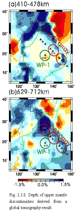
| As examples of research into the Earth interior using seafloor seismic observations, we describe two results from the Mariana LTOBS array observation (MR2001) and a combined study of several observations in the Philippine Sea using a receiver function analysis. The former experiment involved using 10 LTOBS to conduct a 1-year passive observation around the active deep seismic zone to investigate the subduction system. The array detected more than 3000 local events, while the PDE list recorded only about 60. By using a simultaneous inversion method with the event data set, we found that the hypocenter distribution shows a clear deep double seismic zone down to 200 km depth, and determined the velocity structure of the upper mantle (Fig. 2.2.7). The latter study used data from various observations by LTOBS (PHS1999), BBOBS (NOT1), and SBSO (WP-1) in the Philippine Sea (Suetsugu et al., 2005). Fig. 2.2.8 shows the main result: shallow (410 km) and deep (660 km) discontinuities were determined at the site WP-1. Our results also indicate that this variation in depth within the Philippine Sea may be related to the morphology of the stagnant Pacific Slab. |
  |
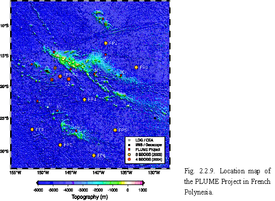
| From 2003 to 2005, we made cooperative land and ocean-floor observations in French Polynesia with IFREE (Institute For Research on Earth Evolution) of JAMSTEC and French scientists (the PLUME Project; Suetsugu et al., 2005). Finally, data from nine of the ten deployed BBOBS were obtained for the entire deployment period with a remarkably low micro-seismic noise level. Preliminary analysis using a receiver function method shows a normal upper mantle discontinuity depth, except for the area around the S2 station that is probably related to the Society Hotspot. Another large-scale observation in the Philippine Sea and northwest Pacific, the Stagnant Slab Project, began in 2005 and is to continue until 2008, using 12 or 16 BBOBS. |
 |
| (1) Permanent network |
| Japanese researchers began to deploy an international seismic network in the Western Pacific region as a part of the POSEIDON (Pacific Oriented SEISmic Digital Observation Network) Project in 1987. The POSEIDON Project is not a large funded project but a non-funded collaboration between individual researchers who are interested in global seismic observations. The observation systems, data formats, and policy for data distribution were not unified, and the POSEIDON network did not essentially function as a single network. |
| After the establishment of the OHRC, we established a unified and modern seismic network (OHP Network) by improving the POSEIDON stations in collaboration with researchers from another institutes. We unified the observation systems to STS-1 and a data logger developed by the Nagoya University. We have also been deploying real-time data transmission systems since 2002. We established the Ocean Hemisphere Project Data Management Center (OHPDMC) to distribute the observational data to the public (see Section 2-6). |
| (2) Portable networks |
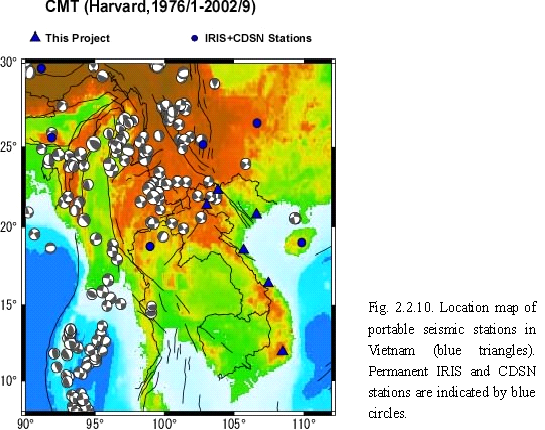
| We are also deploying portable networks to supplement coverage by permanent stations. We developed a data logger that is suitable for portable observations in foreign countries where a sufficient quality of electrical power and communication lines cannot be guaranteed. Our system uses a compact HDD for data storage, which enables long-term and stable observation. Using this system, we deployed portable networks in China (four stations deployed between 1998 and 2003) and Vietnam (six stations deployed since 2001; Fig. 2.2.10). This system was also adopted in other projects (JISNET and SPANET). |
 |
| (3) Education |
| We provided training for our counterparts in maintaining our stations and analyzing observational data. We invited two trainees from Indonesia in 1999 and one from Vietnam in 2002. We also invited 14 trainees from the China Seismological Bureau to train in skills for data analysis. |
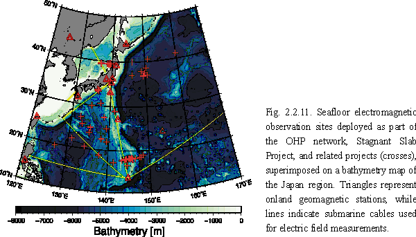
| Electromagnetic observations on the seafloor surrounding Japan have been carried out by the OHP, the Stagnant Slab Project, and related collaborative studies with other institutions (Fig. 2.2.11). These experiments contribute to the study of semi-global scale mantle dynamics in the region by conjunct analysis as well as the study of various tectonic settings. |
 |
| (1) Philippine Sea experiment |
| Six ocean bottom electromagnetometers (OBEMs) were deployed on the seafloor of the West Philippine Basin, the Parece-Vela Basin, and the Mariana Trough in November 1999 and subsequently recovered in July 2000. From these data we estimated the 1-D electrical conductivity structure of the upper mantle at each site (Seama et al., submitted to Phys. Earth Planet. Inter.). The experiment demonstrated the excellent potential of this method to investigate the geothermal structure and water and melt content of the upper mantle. |
| (2) Sea-Floor Electro-Magnetic Station (SFEMS) |
| The SFEMS was developed to achieve continuous seafloor observation of absolute geomagnetic total force as accurately as land-based observatories, including the vector geomagnetic field and horizontal electric field (Toh et al., 1998). The SFEMS has been in operation at 4107f03hN, 15955f43hE in the northwest Pacific Ocean since August 2001. The data collected to date demonstrate that the seafloor observatory can contribute to improving the spatial resolution of the existing geomagnetic observatory network in the middle of the northwest Pacific, where long-term geomagnetic data are lacking (Toh et al., 2004). |
| (3) Mariana experiment |
| Seafloor magnetotelluric (MT) experiments in the central Mariana region have been used to investigate mantle dynamics associated with plate subduction, arc volcanism, and back-arc spreading. A pilot survey was conducted using 10 OBEMs during 2001?2002. The obtained data were inverted, and the resultant electrical conductivity model suggests that the melt generation process within a back-arc spreading axis is similar to that of normal oceanic spreading. Further experiments at 40 sites using 47 instruments began in December 2005 under international collaboration. |
| (4) Japan Sea experiment |
| The aim of this experiment was to image the back-arc mantle beneath the eastern Japan Sea. Six OBEMs were utilized during 2002?2003. Useful data were acquired from four OBEMs and analyzed together with onland data. The obtained conductivity model demonstrates a high conductivity zone that indicates a relationship with the root of the ghot fingersh, which is as cluster-like distribution of volcanoes and low velocity anomalies in northeast Japan. |
| (5) Earthfs electric Field Observation System (EFOS) |
| EFOS was developed with the aim of measuring the electric field of the Earth on the seafloor using a long (10?100 km) cable. It is expected that measurements using EFOS will enable us to detect the electric field that originated from toroidal magnetic mode penetrated from the outer core. A prototype with a 10 km cable (EFOS-10) was installed using JAMSTECfs deep-tow and ROV technology upon the Daito Ridge, West Philippine Basin. Comparison of the data collected over a 1-year period with data from the submarine cable TPC2 and data collected from an OBEM demonstrate the successful operation of the EFOS. |
| (6) Northwest Pacific experiment |
| A 1-year seafloor MT survey using OBEMs was conducted during 2003 with several cruises in the Northwest Pacific Ocean to investigate the electrical conductivity of the upper mantle and transition zone. In this region, a remarkable low-velocity anomaly was imaged from global seismic tomography, and very young (within 1 Ma) intra-plate volcanism was detected (Hirano et al., 2001; Obayashi et al., 2006). One of the goals of this experiment is to elucidate the relationship between these phenomena through the seafloor MT survey. Data have been collected at seven sites to date, and analysis is ongoing. |
| (7) Stagnant slab experiment |
| As part of Stagnant Slab Project, a long-term semi-global scale seafloor MT experiment using OBEMs has been planned to image the mantle transition zone beneath the Philippine Sea, where the subducting Pacific plate appears to have stagnated above the lower mantle. Eleven OBEMs were deployed in October 2005 at sites covering the northern West Philippine Basin, the Shikoku Basin, and the northern Parece-Vela Basin, at ~500 km spacings. This survey is just the first phase of the experiment. The 1-year measurement will be iterated three times to acquire sufficient data to image the transition zone. |
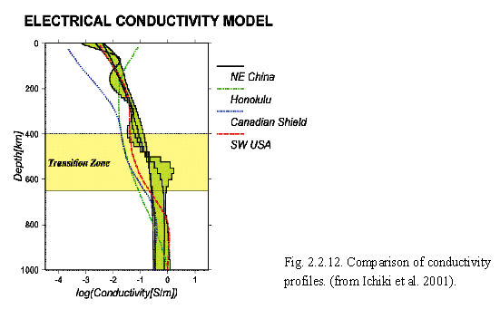
| We have been conducting geo-electromagnetic observations in northeast China to reveal the electrical conductivity structure of the upper mantle, especially around the depth of the mantle transition zone. A highly seismic velocity anomaly documented in the area beneath northeast China?East China Sea is interpreted as a stagnant slab. Understanding the electrical conductivity structure of the back-arc region is essential to consider the physical state of the stagnant slab and the origin of back-arc volcanism in northeast China. |
| Observation of the magnetic field began in 1998 at Changchun, China, and regional-scale electric field observations using retired telephone cables of lengths 20?40 km have been performed since that time in collaboration with the Institute of Geology, China Earthquake Administration. Long-period geomagnetic depth sounding (GDS) and magnetotelluric (MT) responses have been obtained. The responses were then inverted to 1-D electrical conductivity structures that are representative of the structure beneath the magnetic station and cables. The resultant electric conductivity profiles in the Jilin area, China, are shown in Fig. 2.2.12, together with those for Tucson, USA (red dashed line), Carty Lake, Canada (blue dotted line), and Honolulu, USA (green chain-shaped line). It is evident that the mantle transition zone beneath northeast China is significantly more conductive than those of the other areas. Similar patterns of electrical conductivity were observed in the western and central parts of the Liaoning area. |
 |
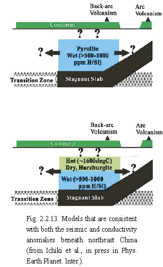
| We calculated profiles of temperature and water content in the upper mantle above the stagnant slab of the Pacific back-arc from the obtained electrical conductivity and seismic P-wave velocity (Vp) structures. Geothermal profiles were determined from the conductivity and seismic structures assuming a dry hartzburgite or dry pyrolite composition. For the deeper part of the upper mantle (depth > 250 km), it is not possible to obtain a geotherm that satisfies both conductivity and seismic structures if dry hartzburgite or pyrolite is assumed. This discrepancy can be explained by allowing for a small amount of water (500?1000 ppm H/Si) in the mantle. In shallower parts of the upper mantle (depth < 250 km), the electrical and seismic geotherms are consistent with each other at 1500?1700 C for dry hartzburgite, whereas they are inconsistent by more than 100 C for dry pyrolite. Alternatively, a wet pyrolite composition applied to the deeper part of the upper mantle also satisfies the electrical conductivity and seismic Vp structures in the shallower part. The proposed models that are consistent with both electrical conductivity and Vp are shown in Fig. 2.2.13. |
 |
| (1) Thermal structure of the Nankai subduction zone, Southwest Japan |
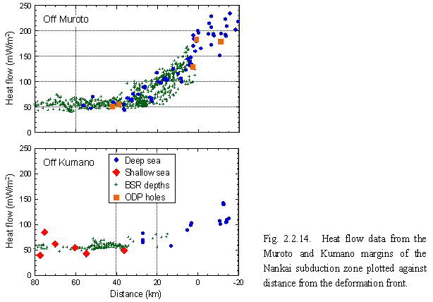
| We have been conducting heat flow measurements in the Nankai Trough area to constrain the boundary condition of a thermal model of the Southwest Japan subduction zone. Concentrated measurements taken off eastern Shikoku (near Muroto) from 1999 to 2001 reveal that heat flow on the floor of the Nankai Trough is extraordinarily high, almost twice as high as the value expected considering the age of the subducting Philippine Sea plate (Fig. 2.2.14; Yamano et al., 2003). In contrast, data recently acquired off the eastern Ki-i Peninsula (near Kumano) show that heat flow on the trough floor in this area is normal. These results indicate that the thermal structure of the subducting plate varies significantly along the margin. We are now collecting data from the trough floor between the Muroto and Kumano areas to delineate the extent of the high heat flow anomaly. |
| Upon the accretionary prism, landward of the trough floor, heat flow profiles across the Muroto and Kumano margins are similar except for in the vicinity of the deformation front (Fig. 2.2.14). Heat flow decreases landward and reaches about 50 mW/m2 at around 40 km from the deformation front. These heat flow profiles provide constraints on the thermal structure of the subduction zone and the amount of frictional heating along the plate interface. Comparison of observational data with the heat flow profiles calculated using subduction thermal models indicates that frictional heating (i.e. effective friction coefficient) is very low in the Nankai subduction zone, consistent with results reported for Cascadia and other subduction zones. |
 |
| (2) Heat flow measurements in shallow seas |
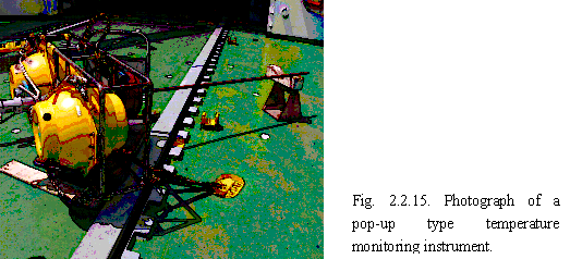
| It is difficult to obtain reliable heat flow measurements in shallow seas where the bottom water temperature is unstable. Long-term monitoring of temperatures in surface sediments may be a practical solution to this problem, and we have developed pop-up type temperature monitoring instruments for this purpose (Fig. 2.2.15). The instrument can measure the sediment temperature profile to a depth of 2 m over a period of about one year. We monitored temperature profiles in shallow sea areas of the Nankai subduction zone and obtained temperature records for over 200 days at seven stations. Analysis of the temperature data show that bottom water temperature variations (BTV) propagated through sediments solely by thermal diffusion. We were then able to remove the influence of BTV from the temperature records and determine the temperature gradient and heat flow at all stations (Hamamoto et al., 2005). The obtained heat flow values generally agree with those estimated from depths of methane hydrate BSRs in the vicinities of the stations. These results demonstrate that long-term temperature monitoring is a useful method for heat flow determination in shallow seas. |
 |
| We also conducted temperature monitoring for about one year at three stations around cold-seep biological communities in the Nankai Trough area, using instruments deployed and recovered by submersibles. We estimated the vertical pore-fluid flow rate and heat flux by analyzing the obtained temperature records. |
| (3) Long-term temperature monitoring in boreholes |
| We have monitored the temperature profile in a borehole drilled into the Nojima fault, an active fault in southwest Japan, since 1997, using the distributed optical fiber temperature sensing technique. The temperature profile has been very stable until the start of a water injection experiment, and we did not detect any thermal effect of the 1995 Hyogo-ken Nanbu Earthquake (Yamano and Goto, 2001). During water injection experiments conducted in 2000, 2003, and 2005, temperature drops associated with the injected water were observed only above about 540 m. This clearly shows that the water leaked out of the hole at this depth (Yamano and Goto, 2005). Changes in the temperature profile were also observed when groundwater was flowing out of the borehole. The shape of the measured temperature profile indicates that the discharging water entered into the hole at the same depth (540 m). |
| (4) Compilation of heat flow data |
| We have been compiling heat flow data from the northwest Pacific area, including the Japanese Islands. The most recent version of the compilation covers an area from 0 to 60N and 120 to 160E, and contains heat flow data from 3195 stations. This data set was published with a list of references in 2004 as part of a CD-ROM (Yamano, 2004). |